Repurposing Public Land for Housing: An Analysis of California’s United States Postal Service Sites
Published On October 17, 2024
Authors: Quinn Underriner and Christi Economy
Introduction
Repurposing public lands for housing development can help to address pervasive housing shortages nationwide. Local, state, and federal policymakers are increasingly pursuing opportunities to make use of underutilized or vacant public properties for housing development.1 Terner Center’s research has highlighted this potential for public, faith-based, and college-owned lands.2 In this short brief, we analyze land the United States Postal Service (USPS) owns in California that might be suitable for housing development.
The brief begins by providing a preliminary analysis of which sites are large enough to accommodate multifamily housing development. Then we identify which of these sites are 1) in a majority residential area, 2) located within half a mile of high-quality transit, and 3) in a geography identified by the state of California as “high resource” based on economic, educational, and environmental metrics. These sites may be particularly promising for new housing. Although all are potentially high quality, they could advance both social and environmental policy goals. The brief concludes by suggesting next steps for USPS leadership interested in evaluating the potential of repurposing USPS land for housing development. We also include an Appendix with more detailed methodology and the limitations of the analysis.
Findings
Across California, USPS owns approximately 474 large (over 20k square feet) sites, totalling over 77.5 million square feet of land 3
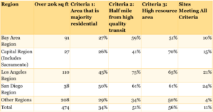
Figure 1: Large USPS Sites by California Region
USPS owns an estimated 603 sites in California, 474 of which are large—defined as at least 20,000 square feet of land. In total, these sites represent 77.5 million square feet, having a mean size of 163,635 square feet and a median size of 87,120 square feet. The sites are spread throughout the state, with the most located in the Los Angeles region (110), followed by the Bay Area (91), and Rural Areas (67) (Figure 1).
Of the 474 large USPS-owned sites, 53 are in majority residential, high resource areas and have access to high-quality public transportation
Assessing land for housing development involves many important considerations. For the purposes of this preliminary analysis, we focus on the following three:
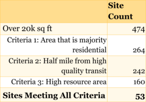
- Majority residential area (264 sites). The land surrounding the site is mostly used for residential purposes (i.e., other people live there), rather than industrial, agricultural, or commercial.4 Building housing in primarily residential areas helps to ensure the necessary infrastructure, local amenities, and community services are already in place.
- Close to public transportation (242 sites). The site is located within half a mile of a high-quality public transportation option—including rails, buses, and ferries.5 Siting new housing near public transit can make it easier for residents to access jobs and amenities, and helps reduce greenhouse gas emissions.
- High resource area (160 sites). Neighborhoods that score well on economic, educational and environmental metrics compared to other neighborhoods in the region.6 These areas have lower poverty rates, higher median home values, access to high-quality schools and employment opportunities, and other benefits that have been shown to improve outcomes for residents.
Fifty-three of the USPS sites meet all three of the above criteria (Figure 2). Given the benefits of developing housing on sites in primarily residential, high resource areas that are close to public transportation, these could be prioritized for further exploration by USPS or policy makers.
Figure 2: Summary of Large USPS Sites in California

Of the 53 sites in high-opportunity, majority residential areas with access to high-quality transit, approximately 36 have at least 10,000 square feet remaining after subtracting out the existing building footprint
Without knowing the details of how potential buildings are situated on the identified sites, it is difficult to assess suitability for affordable housing development. However, to provide a rough estimate of available land, we subtract the building footprint from the total site square footage. After subtracting the building footprint, 30 sites in high-opportunity, majority residential areas with access to high quality transit have at least 20,000 square feet remaining.
Next steps
Going forward, USPS or other interested stakeholders should consider a deeper dive to assess site suitability for housing development for all 603 sites over 20k, prioritizing the 53 sites located in high resource neighborhoods near high-quality transit and other residential development.
This preliminary analysis is subject to a number of limitations (see Appendix). In particular, it will be necessary to confirm the size and positioning of available land to ensure there is adequate space for new construction. It will also be critical to assess site and zoning conditions to identify any constraints to developing housing. Stakeholders may also consider conducting a similar analysis nationwide.
Appendix
Methodology
To identify sites owned by the USPS in California we pulled from two sources: 1) a public USPS list of active facilities, and 2) parcel data from LightBox, a commercial data provider. After geocoding addresses from the active facilities list we matched them to parcels in the LightBox data. We also pulled in additional parcels from LightBox that listed variants of the name “United States Postal Service” as the owner. We consider parcels a part of the same site if they are within 300 feet of each other. To estimate how many of these sites could be suitable for large-scale housing development, we only included large sites—defined as at least 20,000 square feet. With 474 identified, we then overlaid three data layers to learn more about their characteristics:
- Residential Areas. Using data from Replica we matched sites to census tracts and then flagged them based on whether or not they are in a census tract where greater than 50 percent of the land use is residential.
- High Quality Transit. Using California’s map of High Quality Transit Stops, we flagged sites whose centroid is located within half a mile of high quality transit.
- Opportunity Area. Using California’s 2024 Opportunity Map7, we flagged sites located in either the “Highest” or “High” opportunity category as in a high resource area.
Limitations
This analysis is subject to a number of limitations, including:
- Errors in data completeness and quality. The USPS and LightBox data may not include all sites owned by USPS, and/or include errors in the square footage or ownership variables.
- Limited information on building footprints. The analysis does not provide a detailed estimate of how much underutilized land (e.g., undeveloped land and/or excess parking) is available on the identified sites. Sites may include existing structures such as active post offices, which would limit the land available for housing development.
- Lack of information on site and zoning conditions. Our analysis does not capture site conditions such as environmental or topographic constraints that could make a site unsuitable for housing development. It also does not include local zoning regulations, which would influence the feasibility of potential residential development.
Acknowledgements
Thank you to Terner Center colleagues Sarah Karlinsky, Ben Metcalf, and Carolina Reid for their review of this work. Thank you as well to Geraldine Slevin and Chansonette Buck for their assistance on publication.
Endnotes
- Metropolitan Transportation Commission. (2023). “Public Land Reuse.” Retrieved from: https://mtc.ca.gov/planning/housing/public-land-reuse; California Department of Housing and Community Development. (2024). “Public Lands for Affordable Housing Development.” Retrieved from:https://www.hcd.ca.gov/planning-and-community-development/public-lands-affordable-housing-development; The White House. (2024). “FACT SHEET: President Biden Announces Major New Actions to Lower Housing Costs by Limiting Rent Increases and Building More Homes.” Retrieved from: https://www.whitehouse.gov/briefing-room/statements-releases/2024/07/16/fact-sheet-president-biden-announces-major-new-actions-to-lower-housing-costs-by-limiting-rent-increases-and-building-more-homes/.
- Garcia, D. & Sun, E. (2020). “Mapping the Potential and Identifying the Barriers to Faith-Based Housing Development.” Terner Center for Housing Innovation, UC Berkeley. Retrieved from: https://ternercenter.berkeley.edu/research-and-policy/faith-based-housing-development/; Garcia, D.. et. al. (2023). “The Housing Potential for Land Owned by Faith-Based Organizations and Colleges.” Terner Center for Housing Innovation, UC Berkeley. Retrieved from: https://ternercenter.berkeley.edu/wp-content/uploads/2023/08/Faith-Based-Housing-Updated-October-2023.pdf.
- Terner Center analysis of LIHTC projects built between 2020 and 2023 in California indicate that 88 percent of awarded projects were on lots with at least 20k square feet and 98 percent with at least 10k. Data from Shazia Manji, Pratish Patel, Carolina Reid, and Quinn Underriner (2023).“California Low-Income Housing Tax Credit Database, 2020 – 2023.” Cal Poly, San Luis Obispo, and Terner Center for Housing Innovation, Berkeley, California.
- Majority residential areas are defined, using Replica data, as census tracts where at least 50 percent of the parcels are zoned as residential.
- Areas with high-quality transit are defined by California’s Department of Transportation as within half a mile of a high-quality transit stop. These are defined as “An existing rail or bus rapid transit station, a ferry terminal served by either a bus or rail transit service, or the intersection of two or more major bus routes with a frequency of service interval of 15 minutes or less during the morning and afternoon peak commute periods.”
- High resource areas are defined using California’s 2024 Opportunity Map, which captures education, economic, and environmental metrics at the census tract level. Both “Highest” and “High” resource areas are counted here.
- The maps assign each census tract in California to one of four opportunity categories (Highest, High, Moderate, and Low) based on an index of economic, educational, and environmental characteristics that research has shown to be important for improving outcomes for low-income children and adults.

